Japan
Kagawa-ken, Japan — Towns & Travel Guide


Kagawa is Japan's smallest prefecture, a crescent of coast and udon country on the north edge of Shikoku, facing the island-strewn Seto Inland Sea.
About Kagawa-ken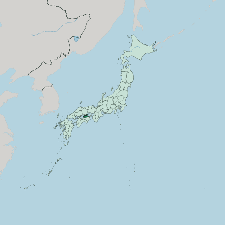


Towns & cities in Kagawa-ken
Pick a town or city — each links to where to stay.
Takamatsu is the natural base, a port city with ferries fanning out to the islands and Ritsurin Garden on its doorstep. Stay there first. Kotohira, inland to the west, suits travellers who want a night in a traditional inn below the steps of Konpira.
Out in the Seto Inland Sea, Naoshima and Shōdoshima each reward an overnight, one for its museums and the other for its olive groves and soy-sauce cellars. Beds are few on the small islands, so book the ryokan and guesthouses well ahead.
About Kagawa-ken
Kagawa is Udon Prefecture.
What is Kagawa-ken known for?
Its chewy Sanuki udon is a pilgrimage food, ladled out in plain counter shops where regulars slurp a bowl standing up before catching the next train. Ritsurin Garden, laid out over generations by the lords of Takamatsu, ranks among the finest strolling gardens in the country. Off the coast lie the art islands.
Naoshima turned a quiet fishing island into a landscape of museums and outdoor sculpture that pulls travellers across the Seto Inland Sea. Pilgrims still climb the long stone stairway to Kotohira-gū, the seafarers' shrine on Mount Zōzu.
Where is Kagawa-ken?
Kagawa is the smallest of Japan's prefectures, folded into the northeast corner of Shikoku. It has a crescent shape. The Sanuki Mountains draw a wall along its southern edge, marking the border with Tokushima to the south and Ehime to the west, while the land tips down northward into the flat, pond-dotted Sanuki Plain.
That plain runs to the water. Along the whole northern side stretches the Seto Inland Sea, the sheltered band of water that separates Shikoku from Honshu. Across that sea lies Okayama, on the main island of Honshu, and since 1988 the Great Seto Bridge has carried road and rail over the strait between them.
The prefecture's islands belong to this sea. Shōdoshima, the second-largest island in the Seto Inland Sea, rises to the northeast, and the smaller Naoshima sits between the two coasts. Ferries thread out from Takamatsu and the mainland to a scatter of smaller islands dotted across the inland water.
Takamatsu anchors the shore as the capital and largest city. Marugame and Kan'onji spread west along the plain, each a short run down the coast from the next.
What is Kagawa-ken like?
Food defines daily life more here than in most of Japan, and it starts with udon. Locals eat Sanuki udon at self-service counters, boiling their own noodles and dressing them from jugs of dashi drawn from dried sardines and soy. Wheat, salt, and soy sauce all come from the region, so the dish is local to its roots.
Kagawa's handwork traditions run just as deep. Marugame turns out most of the round paper uchiwa fans made in Japan, and the plains around Takamatsu grow much of the country's pine bonsai. Out on Shōdoshima, families still press olive oil and age soy sauce in cedar vats.
The islands pull culture the other way, toward contemporary art. Every three years the Setouchi Triennale scatters installations across the Seto Inland Sea, and Naoshima keeps its concrete museums open across the seasons. Faith shapes the calendar as well.
Kagawa holds a stretch of the eighty-eight-temple Shikoku pilgrimage, and Zentsūji marks the birthplace of Kūkai, the monk who founded the Shingon school. In Takamatsu, the Matsudaira lords' Ritsurin Garden still draws walkers along its ponds and clipped pines. It rewards a slow hour.
What is the history of Kagawa-ken?
The land was Sanuki Province long before it was Kagawa, one of the old provinces of Shikoku. Its coast saw history early. In 1185 the Taira and Minamoto clans fought the Battle of Yashima on the shore near Takamatsu, a turning point in the war that ended the Heian age.
Under the Tokugawa shoguns the Matsudaira ruled the Takamatsu domain and a separate lord held Marugame. The modern prefecture was drawn up in 1871, when the domains were abolished. Kagawa was folded into Ehime for a spell, then split off again as its own prefecture in 1888.
What is the climate of Kagawa-ken?
Kagawa sits in the Seto Inland Sea climate zone, sheltered from the rain on both sides. The mountains of Shikoku block the wet southerly winds, and the Chūgoku range across the water on Honshu turns back the northerlies, leaving one of the driest corners of Japan. Rain comes sparingly.
Drought long shaped the Sanuki Plain, and farmers answered it by digging thousands of irrigation ponds across the lowland. The largest of them, Mannō Pond, has stored water since the eighth century. Summers run warm, winters stay mild, and snow rarely reaches the coast.
How do you get to Kagawa-ken?
Most travellers reach Kagawa across the Great Seto Bridge, the rail-and-road link that vaulted the strait from Okayama in 1988. Trains run straight over it. The Marine Liner shuttles between Okayama and Takamatsu in about an hour, tying the prefecture into the fast lines of Honshu.
Takamatsu Airport handles flights from Tokyo and the larger Japanese cities. Ferries still cross the Seto Inland Sea from the mainland at Uno and from Kobe, calling at Takamatsu and the art islands of Naoshima and Shōdoshima. From the station, local lines fan out west to Marugame and inland to Kotohira.
Good for
Updated July 2026