Mexico
Estado de Tlaxcala, Mexico — Towns & Travel Guide


Tlaxcala is Mexico's smallest state, a high volcanic plateau below La Malinche, ringed by Puebla east of Mexico City.
About Estado de Tlaxcala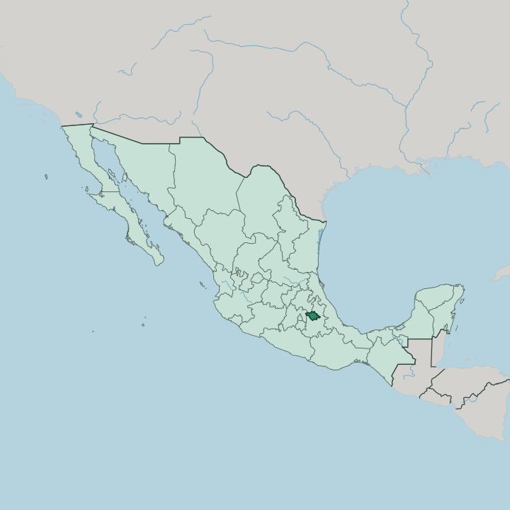


Towns & cities in Estado de Tlaxcala
Pick a town or city — each links to where to stay.
Most visitors base themselves in Tlaxcala de Xicohténcatl, the compact capital whose red-tiled roofs earned it the name Ciudad Roja. The old town is walkable. Its arcaded zócalo and the murals of the Palacio de Gobierno sit within a few minutes of the hotels, while Huamantla, east under La Malinche, fills up for its August fair.
North toward Tlaxco, pulque haciendas and pine ridges reward slower stays, though beds thin out. Choose the capital first; go north to the haciendas when you want quiet.
About Estado de Tlaxcala
Tlaxcala is known above all for its past.
What is Estado de Tlaxcala known for?
Its people allied with Hernán Cortés against the Aztecs, and the state still trades on that history as the cradle of the alliance that brought down Tenochtitlan. The painted murals of Cacaxtla and the terraced Pyramid of the Flowers at Xochitécatl pull in archaeology travellers. The dormant La Malinche volcano towers over everything to the south.
Each August, Huamantla carpets its streets. Pulque, the milky drink tapped from maguey, still flows from the old haciendas that once made the region wealthy.
Where is Estado de Tlaxcala?
Tlaxcala is the smallest of Mexico's states, a landlocked wedge of high country in the east-central part of the republic. It sits on the central Mexican plateau, most of it above the Valley of Mexico that lies to the southwest. The state of Puebla wraps around it to the north, east and south, Hidalgo touches its northwest corner, and the State of Mexico closes the western side.
There is no coast anywhere near. The land belongs to the Trans-Mexican Volcanic Belt, the chain of volcanoes that crosses the middle of the country, and the ground shows it: ridges, deep barrancas, and old lava run through the plateau. La Malinche rises over the southern edge, a dormant volcano that Nahuatl speakers still call Matlalcuéyetl.
It is one of the highest summits in the country and the shape every road in the state seems to point toward. Water gathers in the Zahuapan, which starts behind the Atlangatepec dam in the north and runs south to meet the Atoyac near the city of Puebla. Mexico City lies roughly two hours west by road.
The capital, Tlaxcala de Xicohténcatl, stands near the middle of the state where the plateau opens out. Small it may be. Few Mexican states pack as much varied ground into so little space.
What is Estado de Tlaxcala like?
Life in Tlaxcala turns on a history few other places share. Its people fought beside the Spanish, and for centuries the rest of Mexico called them traitors for it, though Tlaxcaltecs have long worn the alliance as pride rather than shame. Nahuatl is still spoken in the villages around the volcano.
That older world survives in the kitchen most of all. Cooks here claim a founding role in Mexican food, and the markets still sell barbacoa, mixiotes, and escamoles gathered from ant nests in the maguey. Pulque ties past to table.
The fermented maguey sap, once the wealth of the great haciendas, still pours in country taverns across the north. Festivals carry the same intensity. On one August night in Huamantla, called the night nobody sleeps, townsfolk lay carpets of dyed sawdust and petals along the streets for a procession that tramples them by dawn.
Carnival brings out the huehues, masked dancers in feathers and mirrors who mock the old colonial gentry. Tlaxcala's handwork runs just as deep as its table and its festivals. San Pablo del Monte turns out painted Talavera, Apizaco carves walking canes, and the ranches around Huamantla raise fighting bulls.
It is a small state with loud traditions.
What is the history of Estado de Tlaxcala?
People have farmed this plateau for a very long time. Around the year 700, the Olmec-Xicalanca raised Cacaxtla, whose battle murals still hold their color. Centuries later four Nahua lordships joined into the republic of Tlaxcallan, which the Aztec Triple Alliance ringed but never conquered, wearing it down instead through the ritual Flower Wars.
When Hernán Cortés landed in 1519, its lords chose alliance over destruction, and Tlaxcalan armies helped bring down Tenochtitlan in 1521. Spain rewarded the loyalty with rare privileges. Tlaxcala entered the Mexican federation as a state in 1857.
What is the climate of Estado de Tlaxcala?
Altitude sets the weather here, not the tropics. Tlaxcala sits high enough that its climate stays temperate and dry through much of the year, mild by day and cold after dark. Rain arrives on a schedule, falling in heavy afternoon storms from June into September and then all but stopping.
Winters bring frost to the plateau and the flanks of La Malinche, whose upper slopes carry pine forest and, some mornings, a dusting of snow. Nights turn cold whatever the season.
How do you get to Estado de Tlaxcala?
No airliners land in Tlaxcala itself. Most travellers fly into Mexico City and drive about two hours east, or use Puebla's Hermanos Serdán airport just over the state line, barely an hour to the south. Frequent buses run up from Puebla to the capital and to Huamantla.
The old railway from Mexico City to Veracruz built Apizaco as its mountain junction, and highways now trace the same corridor across the state. Rent a car for the haciendas and the volcano.
Good for
Updated July 2026