Mexico
Estado de Hidalgo, Mexico — Towns & Travel Guide


Estado de Hidalgo runs from the Toltec pyramids of Tula through Pachuca's silver mountains to the thermal pools of Grutas de Tolantongo.
About Estado de Hidalgo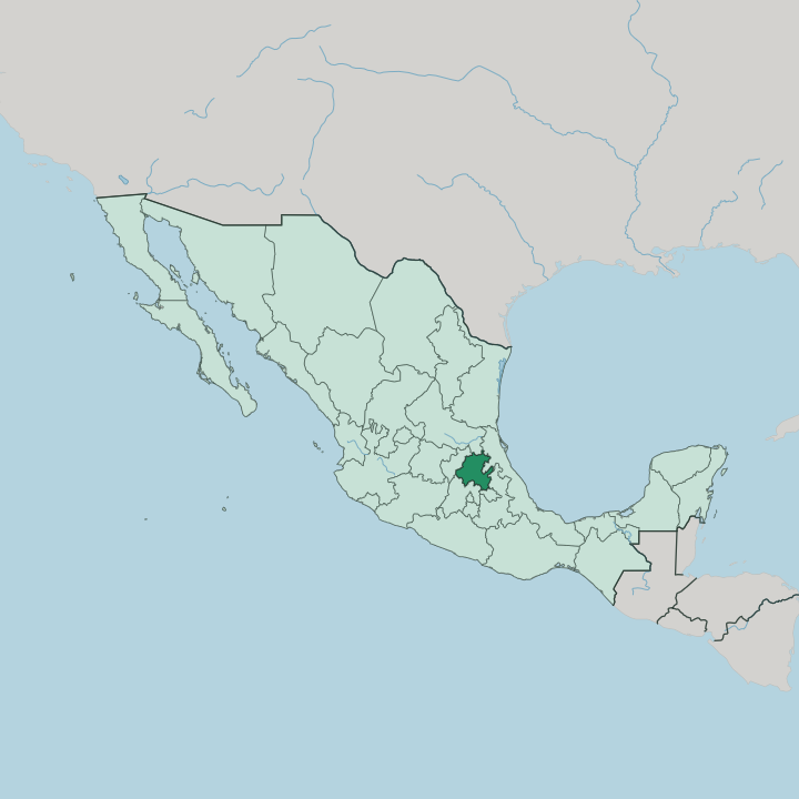


Towns & cities in Estado de Hidalgo
Pick a town or city — each links to where to stay.
Hidalgo has no resort strip. Travellers pick a base by interest instead, and the choice runs from silver towns in the mountains to a hot-spring canyon down in the desert. Pachuca, the capital, sits below its old silver headframes and makes a first stop for the mining country.
Just above it, Real del Monte keeps its Cornish streak. Choose Huasca de Ocampo for the Prismas Basálticos, or the canyon pools of Grutas de Tolantongo deep in the Mezquital Valley.
About Estado de Hidalgo
Four draws pull travellers in.
What is Estado de Hidalgo known for?
At Tula, the Toltec capital, colossal stone warriors called the Atlantes stand on a pyramid that outlasted its city. The twin silver towns of Pachuca and Real del Monte carry a Cornish streak left by miners from England, down to the pastes sold on every corner. Deep in the Mezquital Valley, the hot springs of Grutas de Tolantongo fill a turquoise river and a cliff-face pool.
Near Huasca de Ocampo, the first town Mexico named a Pueblo Mágico, the Prismas Basálticos drop in basalt columns beside a waterfall.
Where is Estado de Hidalgo?
Hidalgo lies in the mountains north of Mexico City, a compact state wrapped around the southern end of the Sierra Madre Oriental. Querétaro borders it to the west. San Luis Potosí and Veracruz run along the north and east, while Puebla, Tlaxcala and the Estado de México close it off to the south. The great range crosses the middle of the state on a diagonal, throwing up the Sierra Alta and the Sierra Gorda and folding the land into deep canyons. The Barranca de Metztitlán cuts one of the deepest, a cactus-walled gorge protected as a biosphere reserve.
Little of Hidalgo is flat. That spine splits the state into three worlds. Around Pachuca and Real del Monte the land is high, cold and mineral, a country of pine ridges and old silver shafts.
West of there the Mezquital Valley opens dry and pale, a semi-arid basin of maguey and organ-pipe cactus that has been Otomí ground for centuries. Drop off the northern edge and everything changes: the Huasteca falls away in wet, green lowland toward the Gulf, drained by the Moctezuma River on its way to the Pánuco. Two more names anchor the map.
El Chico National Park guards a fir forest of rock towers above Mineral del Chico, and the Prismas Basálticos step down a ravine near Huasca de Ocampo.
What is Estado de Hidalgo like?
Two heritages sit side by side in Hidalgo, and they rarely meet elsewhere in Mexico. One is Cornish. When silver-mining companies from England reopened the Pachuca and Real del Monte lodes, Cornish miners came with them, and they left behind the paste, an English cemetery on a Real del Monte hillside, and the first football ever kicked in Mexico.
The other heritage is Mesoamerican and older by far. Barbacoa, the state dish, is lamb wrapped in maguey leaves and steamed in an earth pit, and it comes with pulque, the milky maguey beer fermented on the old estates of the Llanos de Apan. Escamoles, the pale ant larvae harvested from agave roots, still reach the market stalls.
The old cultures hold hardest at the two ends of the state. Otomí families farm the Mezquital Valley and stitch the tenango, a cloth crowded with bright embroidered animals that takes its name from Tenango de Doria. Up in the Huasteca, Nahua and Tének towns keep Xantolo, the Day of the Dead observed with masked dances and marigold altars.
Faith left its mark in stone as well. Massive Augustinian monasteries went up at Actopan, Ixmiquilpan and Metztitlán in the century after the conquest, and the Aqueduct of Padre Tembleque still carries its arches across the southern plain. Tulancingo gave the country its most famous masked man of all: the silver-masked wrestler El Santo.
What is the history of Estado de Hidalgo?
Hidalgo's story starts long before the state existed. At Tula, the Toltec raised the capital that rose between the fall of Teotihuacan and Aztec Tenochtitlan, and their basalt warriors still guard its pyramid. Silver made the rest.
The colonial mines of Pachuca and Real del Monte drew Spanish and then Cornish money, and the veins under the Sierra Madre Oriental proved among the richest in New Spain. Statehood came late. Benito Juárez split Hidalgo from the sprawling Estado de México in 1869 and named it for Miguel Hidalgo, the priest whose cry opened the war of independence.
What is the climate of Estado de Hidalgo?
Altitude writes the weather here. Pachuca sits high and cool, earning the nickname La Bella Airosa for the wind that pours off the Sierra Madre Oriental, and its winter nights drop toward frost. Down in the Mezquital Valley the air turns dry and hot, a semi-arid country where rain is scarce and the maguey thrives.
The Huasteca is the opposite again: low, humid and green, soaked by heavy rains that roll in off the Gulf. Almost everywhere the wet months run through the summer, and the winter stays dry.
How do you get to Estado de Hidalgo?
Hidalgo has no airport of its own worth the name, so almost everyone comes overland from Mexico City. The capital lies about 90 kilometres south, ninety minutes up the toll highway to Pachuca. Two Mexico City airports feed that road.
The older Benito Juárez and the newer Felipe Ángeles both lie on the northern side of the capital, and Felipe Ángeles sits closer to the state line. ADO coaches leave the city every half hour. From Pachuca the highways fan out to the ruins at Tula, the canyon pools of Grutas de Tolantongo and the deep Huasteca.
Good for
Updated July 2026