Japan
Mie-ken, Japan — Towns & Travel Guide


Mie Prefecture runs down the eastern Kii Peninsula, seat of Ise Jingū and the pearl bays of Ise-Shima on Japan's Pacific coast.
About Mie-ken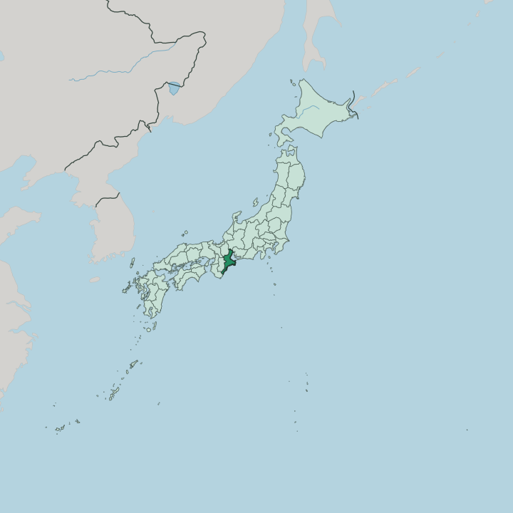


Towns & cities in Mie-ken
Pick a town or city — each links to where to stay.
Most first visits base at Ise, walking distance from the Naikū shrine and the old Oharai-machi lane that leads to it. For the coast, Toba sits at the Shima Peninsula's northeast tip on Toba Bay, while Kashikojima lies south among the pearl rafts of island-strewn Ago Bay, both within Ise-Shima National Park. Iga suits travellers chasing ninja history and Matsuo Bashō's birthplace up in the inland hills.
Short on time? Yokkaichi and the capital Tsu line the northern shore of Ise Bay, closest to the trains from Nagoya. Pick the shrine town first.
About Mie-ken
The name Mie means Ise Jingū to most Japanese.
What is Mie-ken known for?
The shrine complex at Ise, dedicated to the sun goddess Amaterasu, is torn down and rebuilt from fresh cypress every twenty years, and it counts as the holiest site in Shinto. Beyond it the prefecture trades on variety. Ago Bay grows cultured pearls, Matsusaka fattens some of Japan's costliest beef, and the Suzuka Circuit hosts Formula One.
Iga keeps its ninja lineage alive. It is a lot of reputations for one prefecture.
Where is Mie-ken?
Mie forms the eastern flank of the Kii Peninsula, the blunt headland that hangs off southern Honshu into the Pacific Ocean. It belongs to the Kansai region, though it faces east. The northern third is flat and industrial, spread along the western shore of Ise Bay where the Kiso Three Rivers, the Kiso, the Nagara, and the Ibi, empty into the sea near Kuwana. Aichi Prefecture and the city of Nagoya sit across that bay.
Behind the plain, the Suzuka Mountains wall off the northwest, marking the border with Shiga Prefecture and the old road to Kyoto. South of the plain the land tilts and narrows. The Shima Peninsula breaks into a drowned coast of inlets and coves, with Ago Bay the deepest of them.
Farther down, steep forested ridges drop straight to the surf along the Kumano coast, and more than a third of the prefecture lies inside natural parks. Mie is long and thin. It stretches far from the Kiso rivers in the north down to the Wakayama border in the south, hemmed by Gifu to the north, Nara to the west, and Wakayama to the southwest.
The whole eastern edge is water.
What is Mie-ken like?
Faith runs through Mie more visibly than through most of Japan. Ise Jingū draws millions of pilgrims a year to its cypress halls, and every second decade the shrine is rebuilt beside itself on an empty plot, a ritual that keeps carpentry and thatching skills alive across generations. Down the coast at Futami, two rocks joined by a heavy straw rope stand in the shallows as Meoto Iwa, the wedded rocks.
The old pilgrim trail south, the Kumano Kodō, still threads the forests toward the Kumano shrines. Walkers still follow it. Food and craft carry the rest.
Off Toba and Shima, ama divers, mostly women, still free-dive for shellfish and once tended the pearl beds by hand. Matsusaka's cattle are raised on beer and massage into some of the country's richest beef, while Iga guards a stranger heritage of ninja and gave Japan the wandering haiku poet Matsuo Bashō. Local tables run to chewy Ise udon and tekone-zushi, marinated fish over rice.
The everyday language is Japanese. It all sits within easy reach of Nagoya, yet Mie feels older and slower than the industrial belt across the bay.
What is the history of Mie-ken?
Modern Mie is a Meiji-era invention. It was assembled in 1876 from four old provinces, Ise, Shima, Iga, and a slice of Kii, that had never shared a single ruler. Long before that, Ise Jingū made the region a spiritual capital, and during the Edo period whole villages walked the Ise roads on mass pilgrimages known as okage-mairi.
Iga, meanwhile, bred the ninja clans that hired out to warlords in the Sengoku wars. Four provinces became one line on the map.
What is the climate of Mie-ken?
Mie splits into two climates. The Ise Bay plain in the north is humid and temperate, warm in summer and cool when winter winds spill off the Suzuka Mountains, which can hold snow. The south is another country.
Warm, wet air off the Pacific piles against the Kii ranges, and the port of Owase catches some of the heaviest rainfall anywhere in Japan. Typhoons come ashore here in late summer. The coast stays mild through winter.
How do you get to Mie-ken?
Mie has no airport and no bullet-train stop of its own. Nearly everyone comes through Nagoya, just across Ise Bay in Aichi, and its Chūbu Centrair airport even runs a fast ferry straight across the water to Tsu. From Nagoya the private Kintetsu line and JR trains fan south through Yokkaichi and the capital to Ise, Toba, and the pearl coast at Kashikojima.
Expressways trace the same route. The deep south is slower going.
Good for
Updated July 2026