Mexico
Estado de Nayarit, Mexico — Towns & Travel Guide


Nayarit is a Pacific-coast state of western Mexico, running from the Sierra Madre Occidental down to the surf towns of the Riviera Nayarit.
About Estado de Nayarit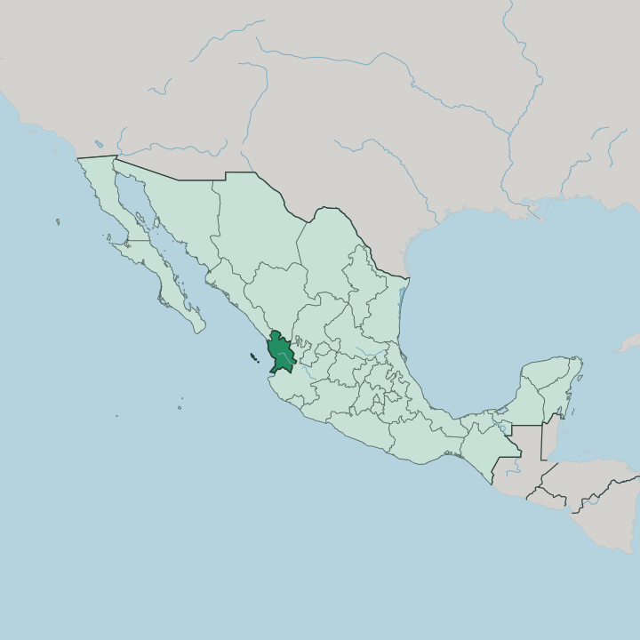


Towns & cities in Estado de Nayarit
Pick a town or city — each links to where to stay.
Where you base depends on which Nayarit you came for. Most beach trips land at the Puerto Vallarta airport and settle into Nuevo Vallarta, the resort-and-marina strip on Bahía de Banderas across the state line. North of the bay, Punta de Mita keeps the luxury headland hotels, while Sayulita and neighbouring San Pancho draw surfers to their point breaks.
Inland lies Tepic. The capital is the springboard toward the Sierra Madre Occidental and the Huichol highlands behind it. Choose coast or sierra.
About Estado de Nayarit
What is Estado de Nayarit known for?
Nayarit's name travels on its coastline. The Riviera Nayarit strings resorts and surf towns along the Pacific Ocean north of Puerto Vallarta, from the luxury peninsula of Punta de Mita to bohemian Sayulita and the boat-day snorkelling of the Islas Marietas. Inland, the capital Tepic sits below the Sierra Madre Occidental, a market town for the Huichol and Cora peoples whose beadwork and yarn paintings carry the state's art abroad.
Surf, sand, and sierra define it.
Where is Estado de Nayarit?
Nayarit occupies a stretch of Mexico's Pacific coast in the west of the country, one of the smaller Mexican states. The Pacific Ocean forms its whole western edge, a shoreline of nearly 200 miles of beaches, river mouths, and mangrove lagoon. Sinaloa lies to the northwest and Durango to the north, Zacatecas wraps the northeastern corner, and Jalisco borders it to the south and east. The Sierra Madre Occidental crosses the state from the northwest, dropping in deep barrancas toward a narrow coastal plain.
Two volcanoes, Ceboruco and Sangangüey, rise from that broken country. Height and coast sit close together here. The Río Grande de Santiago is the great river of Nayarit, carrying the outflow of Lake Chapala down through the highlands and out to the sea near San Blas.
Its floodplain and the coastal Marismas Nacionales form one of the largest mangrove wetlands on the Pacific coast of the Americas, a refuge for waterbirds. Offshore, the Islas Marietas sit at the mouth of Bahía de Banderas, and the volcanic Islas Marías lie further out to sea. The island town of Mexcaltitán rests in a lagoon in the north.
Rivers order this land.
What is Estado de Nayarit like?
Two Mexicos overlap in Nayarit. In the high country of the Sierra Madre Occidental live the Huichol, who call themselves Wixárika, and the Cora, or Naayeri, whose communities kept their own governance and religion through centuries of resistance. Huichol art is the state's best-known export: yarn pressed into beeswax to make glowing paintings, and beadwork covered in deer, maize, and peyote drawn from their ceremonial life.
Santiago Ixcuintla, on the coastal plain, holds a cultural centre that supports Huichol artists who come down from the mountains to sell and to work. The sierra keeps its own calendar. On the coast the mood turns to fishing towns, banda music, and long lunches of pescado zarandeado, whole fish splayed and grilled over mangrove wood.
The lagoon island of Mexcaltitán, laid out on a grid of canals that flood in the rains, is held by tradition to be Aztlán, the homeland the Mexica left on their march south to found Tenochtitlán. Whether or not the legend holds, it anchors a strong local identity. Shrimp from the Marismas Nacionales, tobacco from the fields around Santiago Ixcuintla, and coffee off the sierra slopes all pass through the same coastal markets.
Faith here mixes Catholic saints with older mountain gods. Food, water, and pilgrimage run through it.
What is the history of Estado de Nayarit?
Nayarit takes its name from Nayar, a Cora leader, and the sierra behind the coast held out longer than almost anywhere in Mexico. Spanish control came late and never went unchallenged; the last independent Cora communities were subdued only in 1722. After independence the region was governed as part of Jalisco, and in the mid-nineteenth century the peasant revolt led by Manuel Lozada burned across it.
Benito Juárez carved out a Military District of Tepic in 1867, raised to a federal territory in 1884. Full statehood came in 1917. The mountains were always the hard part.
What is the climate of Estado de Nayarit?
Nayarit runs hot and tropical along the coast, with the year split into a dry half and a wet one. The rains arrive around June and last into October, peaking in the late-summer downpours that fill the Río Grande de Santiago and green the mangroves. From November onward the coast turns dry and bright.
Up in the Sierra Madre Occidental the air cools with height, so Tepic stays milder than the beaches below. Pacific storms track past the shore in late summer. Heat and rain keep to a schedule.
How do you get to Estado de Nayarit?
The usual way in is by air. Flights land at the Puerto Vallarta airport just over the Jalisco line, and it is a drive of about an hour north from there into the Riviera Nayarit. Tepic keeps its own smaller airport for domestic routes.
By road, a toll highway climbs inland from Guadalajara to Tepic before dropping back down to the coast, and long-distance buses run the length of the shore. North of Bahía de Banderas, local vans link the coastal towns along the old highway. You arrive by wheels.
Good for
Updated July 2026