Mexico
Estado de Tamaulipas, Mexico — Towns & Travel Guide


Tamaulipas is Mexico's north-eastern corner, where the Río Bravo del Norte, the Sierra Madre Oriental, and the Gulf of Mexico frame the state.
About Estado de Tamaulipas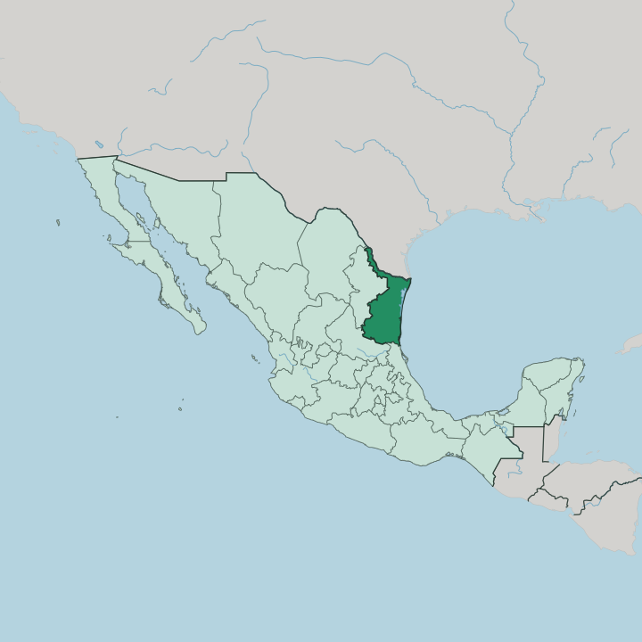


Towns & cities in Estado de Tamaulipas
Pick a town or city — each links to where to stay.
Beds here cluster in working cities, not beach resorts. Geography makes the choice. Tampico and its twin Ciudad Madero hold the Gulf shore, trading seafood, oil-era plazas, and the long sands of Playa Miramar within reach of the nearest airport to El Cielo.
Ciudad Victoria sits inland beneath the Sierra Madre Oriental, the natural road head for anyone climbing to the cloud forest above Gómez Farías. Along the Río Bravo del Norte, Reynosa, Matamoros, and Nuevo Laredo run on cross-border trade with Texas. Choose the coast, or turn inland for the mountains.
About Estado de Tamaulipas
Trade defines Tamaulipas.
What is Estado de Tamaulipas known for?
Three of Mexico's busiest border crossings line the Río Bravo del Norte, and Nuevo Laredo alone moves more truck freight than any other land port on the continent. The state is equally known for Tampico, the Gulf port whose early oil wealth left a centre of New Orleans-style ironwork and arcaded plazas. Inland, the Sierra Madre Oriental hides El Cielo, a cloud forest that marks the northern limit of tropical woodland in Mexico.
The port of Tampico only lent its name to carne asada a la tampiqueña; a restaurateur who had lived there created the grilled-beef plate in Mexico City.
Where is Estado de Tamaulipas?
Tamaulipas fills the north-eastern corner of Mexico, where the coastal plain runs down to the Gulf of Mexico. Its northern edge is a river. The Río Bravo del Norte, the Rio Grande on the far bank, divides the state from Texas along its whole northern boundary before emptying into the sea near Matamoros. Nuevo León lies to the west, San Luis Potosí to the south-west, and Veracruz to the south.
The Gulf shore stretches for hundreds of kilometres, screened for much of its length by the Laguna Madre, a shallow hypersaline lagoon walled off from the open water by long barrier sand. Land climbs from the coast toward the west. The Sierra Madre Oriental raises limestone ridges above the plain behind Ciudad Victoria, cresting past three thousand metres farther south-west around Miquihuana.
Two smaller ranges stand apart from that wall, the Sierra de Tamaulipas and the Sierra de San Carlos, rising in isolation out of the eastern lowland. Rivers drain the whole state eastward to the Gulf. The Guayalejo, the Purificación, and the San Fernando cross the plain, while the Pánuco reaches the sea at Tampico in the far south.
Everything tilts to the coast.
What is Estado de Tamaulipas like?
Tamaulipas splits in three, and its culture splits with it. The north is norteño country. Accordion-and-bajo-sexto conjuntos, ranch dances, and the beef-and-cabrito table of the cattle plains set the tone from the Río Bravo del Norte down toward the Sierra Madre Oriental.
The south belongs to the Huasteca, the humid indigenous region shared with Veracruz and San Luis Potosí, where trios play son huasteco and the high falsetto of the huapango carries over the fiddle. Between them, the Gulf coast keeps its own port culture around Tampico and its twin Ciudad Madero. Each corner keeps its own festivals, its own dishes, and its own sound.
Food follows the same three lines. Border kitchens grill carne asada and roast whole kid goat over open coals. The coast turns to the Gulf of Mexico for red snapper, shrimp, and the stuffed blue crab called jaiba rellena.
Tampico put its own name on the national menu with carne asada a la tampiqueña, a thin grilled steak plated with strips of poblano chile, cheese, and refried beans. Spanish is the common tongue across all three. The blend of all three is what makes Tamaulipas itself.
What is the history of Estado de Tamaulipas?
Spain came late to this coast. For two centuries the Gulf lowland stayed beyond real colonial control, until José de Escandón was sent north in 1748 to plant towns and missions along the Río Bravo del Norte and the rivers below it. He called the new province Nuevo Santander, after his home region in Spain.
Independence redrew the map. In 1824 the province was renamed Tamaulipas, from a Huastec word for the high hills, and joined the young Mexican republic as one of its nineteen founding states.
What is the climate of Estado de Tamaulipas?
Two climates share one state. The north and the interior basins run dry, semi-arid country where the town of Jaumave, at the desert edge below the Sierra Madre Oriental, sees only a thin band of rain each year. The south is another world.
Where the range lifts the Gulf air near Gómez Farías, the El Cielo reserve drips with cloud forest, the northernmost in Mexico, soaked by heavy summer rain. Along the coast the Gulf of Mexico keeps the air warm and humid, and late-summer storms blow in off the water. Across Tamaulipas, warmth is the one thing that never lets up.
How do you get to Estado de Tamaulipas?
Most travellers reach Tamaulipas overland from Texas. International bridges do the work. Nuevo Laredo carries the busiest truck traffic of any land port on the continent, while Reynosa faces McAllen and Matamoros faces Brownsville across the Río Bravo del Norte.
Airports at Tampico, Ciudad Victoria, and the border cities link the state to Mexico City and Monterrey by air. Ships still call at the deep-water port of Altamira, beside Tampico on the Gulf of Mexico. From there, highways climb west into the Sierra Madre Oriental.
Updated July 2026