Japan
Iwate, Japan — Towns & Travel Guide


Iwate is the Pacific-facing north-east of Japan's Honshu, a mountainous Tōhoku prefecture of high peaks, a broad river basin, and a cliff-torn coast.
About Iwate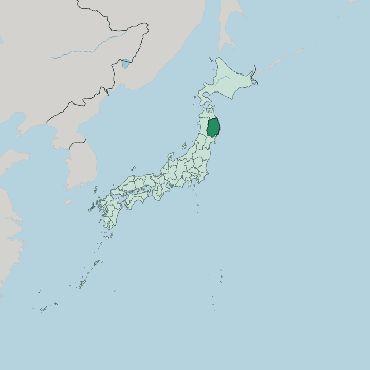


Towns & cities in Iwate
Pick a town or city — each links to where to stay.
Most trips start in Morioka. The capital sits where the Kitakami River meets the Nakatsu under Mount Iwate, and its Shinkansen station makes the easiest first base. South down the valley, Hiraizumi sits within walking distance of Chūson-ji and the golden Konjikidō, best if temples and the Fujiwara past are the point.
For hot springs, the inns of Hanamaki Onsen gather on the plain in the birthplace of the poet Kenji Miyazawa. Out east, the Sanriku Coast trades city comforts for fishing-port nights near the white rocks of Jōdogahama. Pick the valley for sights and trains, the coast for sea and quiet.
About Iwate
Two names carry Iwate.
What is Iwate known for?
Hiraizumi, in the south, was the seat of the Northern Fujiwara, and its Chūson-ji temple still holds the gold-leafed Konjikidō hall that made the town a UNESCO World Heritage Site. Morioka, the capital, sits under the cone of Mount Iwate where the Kitakami River gathers, an old Nanbu castle town famous for wanko soba served in endless small bowls. East of the mountains the Sanriku Coast breaks into cliffs, sea caves, and fishing bays.
Space is the other headline: only Hokkaidō is a larger prefecture.
Where is Iwate?
Iwate fills the Pacific side of northern Honshu, in the Tōhoku region at the top of Japan's main island. Only Hokkaidō is a bigger prefecture. Two mountain chains run down it from north to south.
The Ōu Mountains, the longest range in Japan, form the western wall along the border with Akita Prefecture; the lower Kitakami Mountains rise between the interior and the sea. Between them the Kitakami River, one of the longest in the country, drains the length of the prefecture and lays down the wide, fertile basin where Morioka and most of the towns and farms sit. Mount Iwate, the volcano locals call Nanbu Fuji, stands over the capital and marks the range's high point.
East of the Kitakami hills the land drops to the Pacific Ocean. This is the Sanriku Coast. Cliffs, sea caves, and deep bays cut the shoreline, and fishing ports tuck into the inlets between headlands such as Jōdogahama near Miyako.
Cape Todo, the easternmost point of all Honshu, reaches out here toward the sea. Aomori Prefecture closes the north and Miyagi Prefecture the south, while the mountains wall off Akita in the west. The sea shapes the east as firmly as the peaks shape the west.
What is Iwate like?
Iwate's culture reaches back to a golden age. In the south, the Northern Fujiwara built Hiraizumi in the twelfth century as an earthly image of the Buddhist Pure Land, and Chūson-ji still guards the gold-leafed Konjikidō raised over their tombs. That legacy earned the town its place on the World Heritage list.
The castle towns kept their own traditions. Morioka, seat of the Nanbu lords, gave its name to Nanbu ironware, the heavy cast-iron kettles and teapots still hammered out across the prefecture. Lacquerware and pottery come from the same workshops.
Food here is plain and generous. Wanko soba turns a meal into a game, waiters refilling small bowls of buckwheat noodles until the eater caps them. Two more famous noodles belong to the capital, the chewy jajamen and the cold, spicy reimen.
The land bred storytellers too. Hanamaki raised Kenji Miyazawa, whose poems and children's tales imagined an ideal Iwate he named Ihatov, while the farm town of Tōno gathered the folk legends, kappa water-spirits among them, that Yanagita Kunio set down in print. Japanese is the language, spoken with a broad northern accent.
What is the history of Iwate?
Iwate's story turns on two power centres. From 1087, four generations of the Northern Fujiwara ruled much of the north from Hiraizumi, until Minamoto no Yoritomo destroyed the clan in 1189 and folded the region into his new order. Centuries later the Nanbu lords built Morioka Castle and ran the Morioka Domain through the Edo peace.
The prefecture itself was drawn in 1876 under the Meiji reforms. Modern history is harder: the Sanriku Coast has been struck again and again by tsunami rolling in off the Pacific, none worse than the great wave of 2011.
What is the climate of Iwate?
Iwate keeps a cold, four-season climate. Winters are long and snowy, hardest inland around Morioka and the Ōu Mountains, where the powder that feeds the ski slopes piles up from December. Summers are short and warm in the Kitakami basin.
The coast plays by its own rules: a cool sea wind called the yamase can drift in off the Pacific through summer, holding the Sanriku Coast grey and chilly while the interior bakes. Snow, sea fog, and clear autumn light each take their turn.
How do you get to Iwate?
Most travellers ride the rails north. The Tōhoku Shinkansen runs from Tokyo straight up the Kitakami valley to Morioka in a little over two hours, and local lines branch out from there to Hiraizumi in the south and across the mountains to the Sanriku Coast. Hanamaki Airport handles a handful of domestic flights for those skipping the train.
Beyond Morioka the bullet train carries on toward Aomori and the tunnel to Hokkaidō. From the capital, buses and branch trains do the rest.
Good for
Updated July 2026