Japan
Gunma-ken, Japan — Towns & Travel Guide


Gunma is an inland prefecture in Japan's Kantō region, a mountainous land of hot springs, silk heritage, and the source of the Tone River.
About Gunma-ken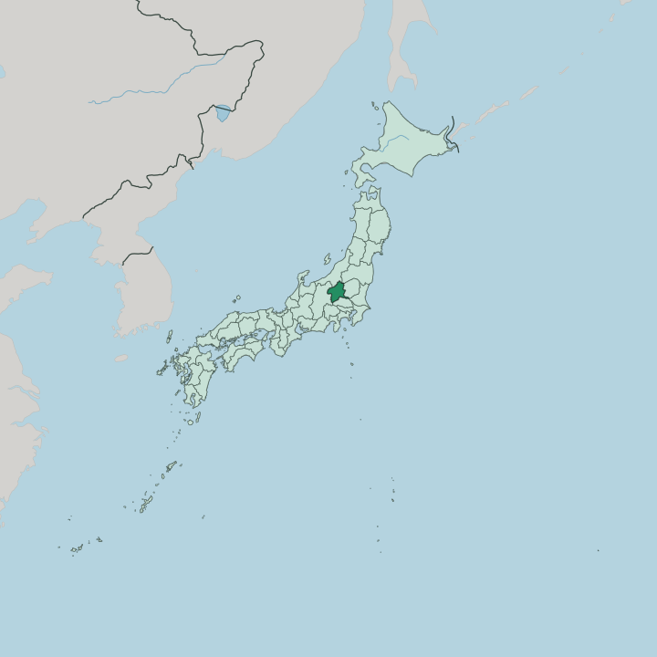


Towns & cities in Gunma-ken
Pick a town or city — each links to where to stay.
Most visitors to Gunma sleep in an onsen town rather than a city. Kusatsu is the headline choice, a hot-spring resort whose ryokan pipe undiluted source water straight from the Yubatake. Ikaho climbs its famous stone steps above Shibukawa, and Minakami spreads through the northern valleys below Mount Tanigawa for anyone drawn to rivers and mountains.
Trains matter to some travellers. Takasaki, the largest city and shinkansen junction, sits closest to the fast lines. Pick the valleys for the baths, the city for the connections.
About Gunma-ken
Gunma is famous above all for hot springs.
What is Gunma-ken known for?
Kusatsu ranks among Japan's three great onsen, and its many sources pour out more natural hot-spring water than any other resort in the country, the steaming Yubatake channelling that flow at the town's centre. The prefecture also holds the Tomioka Silk Mill, a UNESCO World Heritage site where raw silk became Japan's first modern industry. Takasaki, the largest city, gives the country most of its Daruma dolls.
Mountains ring almost every view. The Jōmō Sanzan, Akagi, Haruna, and Myōgi, have drawn worshippers and hikers for centuries.
Where is Gunma-ken?
Gunma sits inland in the Kantō region of Honshu, one of only a handful of Japanese prefectures that touch no sea. It fills the north-western corner of the Kantō Plain. The land tilts from flat to vertical as it runs north and west.
About one seventh of it is protected as natural park. The south-east is lowland, where the cities and rice fields gather; the rest climbs into forested ranges that cover most of the prefecture. Niigata and Fukushima lie across the northern mountains, Tochigi to the east, Saitama to the south, and Nagano beyond the peaks to the south-west. Beyond the lowland, rivers shape the whole prefecture.
The Tone River, the largest river in Japan by catchment, rises in Gunma's northern highlands and gathers the Agatsuma and other streams before crossing the plain toward Tokyo. Volcanoes mark the frontiers. Mount Asama smoulders on the Nagano border, while the old cones of Akagi, Haruna, and Myōgi, the Jōmō Sanzan, stand over the central basin.
High in the north, the marshes of Oze spread across a plateau shared with three neighbouring prefectures. Boardwalks thread that wetland for walkers who come to see its spring blooms. Mountains are never out of sight here.
What is Gunma-ken like?
Silk made Gunma. For a century the prefecture reeled thread that clothed the world, and the Tomioka Silk Mill still stands as the monument to that trade. The old province here was called Kōzuke, also read Jōmō, and the name lingers in everything from the mountains to the local dialect.
Mountain worship runs deep. The peaks of Akagi, Haruna, and Myōgi carry shrines that pilgrims have climbed for centuries. Even the prefectural emblem is three stylised mountains.
Daily life leans on the bath and the table. Ryokan culture is strong wherever hot water surfaces, from Kusatsu to Ikaho, and a soak before dinner is simply how the day ends. Gunma grows most of Japan's konjac, and its wheat plains give the region a deep love of noodles and steamed yaki-manjū buns.
Mizusawa udon, hand-pulled near Ikaho, ranks among the country's famous noodles. Takasaki turns out red Daruma dolls by the thousand, sold as talismans of persistence. Children here grow up reciting the Jōmō Karuta, a card game that drills the prefecture's places and heroes into memory.
Local pride is a taught thing.
What is the history of Gunma-ken?
Long before it was Gunma, this land was Kōzuke Province, one of the old provinces of the Japanese realm. The modern prefecture took shape in 1871, when the abolition of the feudal domains redrew the map of Japan. What followed made the region's name.
In 1872 the new Meiji government raised the Tomioka Silk Mill on the plain, a French-engineered filature that pulled Japan into the industrial age on the strength of raw silk. For decades that thread was the country's largest export, and Gunma's mountains and mulberry fields fed the looms. Silk built the railways, and the railways carried the silk.
What is the climate of Gunma-ken?
Gunma's weather splits with its terrain. The southern plain runs hot and humid through summer, then turns dry and bright in winter, swept by the karakkaze, the hard, dry wind that pours down off Akagi and the northern ranges. Those same mountains wring the snow out of the clouds coming from Niigata, so the lowlands stay sunny while the passes bury themselves.
Head north and it becomes snow country. Minakami and the slopes below Mount Tanigawa lie deep under powder for months. The gap between a Maebashi summer and a mountain winter is wide.
How do you get to Gunma-ken?
Gunma is an easy run from Tokyo. Two bullet-train lines, the Jōetsu Shinkansen and the Hokuriku Shinkansen, share the same track north out of the capital before splitting at Takasaki, which makes that city the prefecture's front door. From Takasaki, local trains and buses branch out to the onsen valleys.
Kusatsu, for one, is reached by rail to Naganohara-Kusatsuguchi and then a mountain bus. Drivers come up the Kan-Etsu Expressway instead. With no coast and no major airport, Gunma is a place reached overland.
Good for
Updated July 2026